- Tibet -
Tibet offers fabulous monasteries, breathtaking high-altitude walks, stunning views of the world’s highest mountains and one of the most likeable cultures you will ever encounter.
For many people, the highlights of Tibet will be of a spiritual nature: magnificent monasteries, prayer halls of chanting monks, and remote cliffside retreats. Tibet’s pilgrims - from local grandmothers murmuring mantras in temples heavy with the aroma of juniper incense and yak butter to hard-core visitors walking or prostrating themselves around Mt Kailash -are an essential part of this appeal. Tibet has a level of devotion and faith that seems to belong to an earlier, almost medieval age. It's fascinating, inspiring and endlessly photogenic.

Basic Information
Chinese Name: 西藏 (Xi Zang)
Location: South-west of China, also bordering India, Nepal, Burma and Bhutan.
Province Captical: Lhasa
Area: 2.5 million square kilometres, which includes U-Tsang, Kham and Amdo provinces. "Tibet Autonomous Region", consisting of U-Tsang and a small portion of Kham, consists of 1.2 million square kilometres. The bulk of Tibet lies outside the "TAR".
Population: The total Tibetan population in Tibet is 6 million. Of them, 2.09 million live in the "TAR" and the rest in the Tibetan areas outside the "TAR".
Average Altitude: 4,000 metres or 13,000 feet above sea level.
Famous City: Lhasa, Nyingchi, Shigstze
Tibet Geography
Located in the southwest of the People’s Republic of China, Tibet Autonomous Region covers an area of more than 1.22 million square kilometers, accounting about one-eighth of Chinese territory. Tibet has a boundary line over 3842 kilometers, surrounded by Xinjiang and Qinghai on the north, Sichuan and Yunnan on the east, Burma, India, Bhutan, Nepal and Kashmir region on the south and west.
Tibet is on a high plateau—the Plateau of Tibet—surrounded by enormous mountain masses. The relatively level northern part of the plateau is called the Qiangtang; it extends more than 800 miles (1,300 km) from west to east at an average elevation of 16,500 feet (5,000 metres) above sea level.
Qinghai-Tibet Plateau, known the roof of the world, consists of the Himalayas, southern Tibet valley, northern Tibet plateau and mountain and canyon area of eastern Tibet. It’s also regarded as the third pole on earth in addition to the North and South poles.
Tibet has a total lake area of about 23.8 thousand square kilometers with over 1,500 lakes of different sizes scattering around valleys and mountains. And many lakes in Tibet are endowed with significant religious meanings. Lake Namtso, Lake Manasarovar and Lake Yamdrok are the three world-known holy lakes.
What's more, Tibet has a very limited amount of arable land and a visit to farmer markets or local farms around Lhasa must be an unforgettable experience.
Tibet Climate
Geographically the Tibetan plateau is known as the roof of the world or third pole of the earth. With an average altitude of 4950m above sea level, the Tibetan plateau is bound by two mighty mountain ranges. The Himalayan range consists of the world highest peak Mt.Everest and is situated from south to west. The Thanggula range in the north consists of alpine terrain conditions, severe, dry and continental climate in Tibet. With strong winds, low humidity, a rarefied atmosphere and a huge fluctuation in annual daytime temperatures, the Tibetan plateau is exposed to an unhampered cool arctic air from the north; while the southern tropical and equatorial air masses barely penetrate the Himalayan barrier into Central Asia. The strong heat during the summer months and the freezing in winter produce clear seasonal variations in atmospheric circulation and enhance the role of local centres of atmospheric activity.
Low temperatures are prevalent throughout the western regions. The Indian monsoon exerts some influence on eastern Tibet. Northern Tibet is subject to high temperatures in the summer and intense cold in the winter. All of these conditions make touring through Tibet one of the most incredible and inspirational journeys on earth.
Most of Tibet receives only 460 mm of precipitation (both rain and snow) annually, with much of that falling during the summer months. The Himalayas act as a barrier to the monsoon (rain-bearing) winds from the south, and precipitation decreases from south to north. The perpetual snow line lies at some 4,800 metres in the Himalayas but rises to about 6,100 metres in the northern mountains. Humidity is low, and fog is practically nonexistent.
Temperatures in the higher elevations are cold, but the lower valleys and the southeast are mild and pleasant. Seasonal variation is minimal, and the greatest temperature differences occur diurnally (i.e., during a 24-hour period). Lhasa, which lies at an elevation of 3,650 metres, has a daily maximum temperature of 30 °C and a minimum of −19 °C. The bitterly cold temperatures of the early morning and night are aggravated by the gale winds that blow throughout the area most of the year. Because of the cool dry air, grain can be safely stored for 50 to 60 years, dried raw meat and butter can be preserved for more than one year, and epidemics are rare.
Tibet Culture and Religion
Religion and spirituality is extremely important to the Tibetans and has influence over all aspects of their lives and is deeply ingrained into their cultural heritage. Bon is the ancient traditional religion of Tibet, but following the introduction of Tantric Buddhism into Tibet by Padmasambhava this became eclipsed by Tibetan Buddhism, a distinctive form of Vajrayana. Tibetan Buddhism is practiced not only in Tibet but also in Nepal, Mongolia, parts of northern India, the Buryat Republic, the Tuva Republic, and in the Republic of Kalmykia and some other areas in China.
Before the arrival of Buddhism, the main religion among Tibetans was an indigenous shamanic and animistic religion, Bon, which now comprises a sizeable minority and which would later influence the formation of Tibetan Buddhism.
According to estimates from the International Religious Freedom Report of 2012, most of Tibetans are bound by Tibetan Buddhism, while a minority of 400,000 people are bound to the native Bon or folk religions which share the image of Confucius with Chinese religion, though in a different light.According to some reports, the government of China has been promoting the Bon religion linking it with Confucianism.
There are four mosques in the Tibet Autonomous Region with approximately 4,000 to 5,000 Muslim adherents,although a 2010 Chinese survey found a higher proportion of 0.4%. There is a Catholic church with 700 parishioners, which is located in the traditionally Catholic community of Yanjing in the east of the region.
Folk Festivals
Sho Dun Festival
Sho Dun Festival is one of the traditional Tibetan activities. “Sho Dun” means yogurt in Tibetan language. This festival often starts at the end of June or the beginning of July in Tibetan lunar calendar. Traditional Sho Dun Festival usually has “Buddha display” as the opening ceremony, and then people often go to public places, such as Norbulingka to watch traditional Tibetan opera. At the same times, there is also horse ridding performance and yak race.
New Year’s Festival Losar
It is the most important festival in a year for Tibetan people, and it is similar to Han’s lunar calendar. New Year’s Festival lasts from January 1st to 15th in Tibetan Calendar. Because all the Tibetan people are Buddhism, religious atmosphere is strong even in festivals. In this case, most activities are about sacrifice and pray to Buddha.
Buddha’s sermon
This festival is in April 15th, which is also the birthday of Buddha. On this day, monks put the copper statue of Buddha in water, and people can throw coins to it to pray for future. Also, people will gather to eat vegetarian food, and the meal is mainly noodles, vegetables and wine. Many people asks for the washing water of Buddha’s statue to have bless.
Tibet Travel Tips
Independent Travel is not allowed in Tibet
According to the policy of Tibet travel regulation of the regional Tibet Autonomous Region. All the international visitor are not allowed to travel independently in Tibet. You will have to book the tour service with a local Travel agency in Tibet with the tour guide and the private Vehicles. During your visit to any attractions in Tibet, you will have to accompanied by a licensed tour guide. You can choose to book the hotel by your own self or book it with the agency.
You can either join the group tour or book a private tour as per your interest. When you are in towns like Lhasa, Shigatse, and Nyingtri, you can have free time after visiting the sites.
Tibet travel permit is Required for any traveler coming into Tibet Autonomous Region.
To travel into Tibet Autonomous Region, all the international travelers are required to have Tibet travel permit. This permit many time referred to as Tibet Visa. You will need this permit while boarding for the flights to Tibet from any part of China, you will need a copy of it while boarding any trains or flight to Tibet.
To get the permit, you have to book a Tibet tour with a travel agent, and send your passport and Chinese visa about 20 days in advance, and then the agent will apply for the permit (all Tibet permits can only be applied by travel agency). If you travel to other prefectures like Shigatse, Nyingchi, Shannan, etc, you also have to obtain an Alien Travel Permit.
Some additional Permits are required if you are visiting beyond Lhasa.
Border Permit– It is an additional permit your travel agency need to apply before your arrival in Tibet. If your journey is reaching at the destination in border areas like Mount Everest, Mount Kailash or if you are coming to Tibet from Nepal. This is an additional permit along with the Tibet travel permit. For this permit, it will take only one visit and a few hours to get it.
Military permit – This permit is also applied by your travel agency in Lhasa before your arrival in Lhasa. This permit is required if you are traveling into the military sensitive region of Tibet, Like Ngari Prefecture , Nyinchi Prefecture, Overland journey from/ to Yunan and Qinghai province. This permit will take more than seven days and in total if your journey requires this permit, it will take about a month for all the permit work to be done.
Available Months to Visit Tibet
Generally speaking, months from April to October are recommended. Other months are usually very cold, and possible have heavy snow, especially in regions like Mount Everest, Mount Kailash, Namtso Lake, etc.
What's more,Tibet is normally close from Late February to the end of March every year. During this period the Tibet tourism bureau will be upgrading and maintaining their systems too. which is why they will not issue the Tibet travel permit. They will start making the Tibet travel permit by the beginning of April.
High Altitude Sickness
Altitude sickness, also known as Acute Mountain Sickness(AMS), or altitude illness is common at high altitudes, and depends on the elevation, the rate of ascent and individual susceptibility. Most visitors to Tibet will suffer from at least some symptoms that will generally disappear through acclimatization in several hours to several days. Symptoms tend to be worse at night and include headache, dizziness, lethargy, loss of appetite, nausea, breathlessness and irritability. Difficulty sleeping is another common symptom, and many travelers have trouble sleeping for the first few days after arriving in Lhasa.
The average altitude of Tibet is about 4000 meters above the sea level (Lhasa: 3700m; EBC: 5200m; Namtso: 4718m). You may suffer a bit from High Altitude Sickness in the beginning days of your Tibet trip if you haven’t had rich high plateau travel experience. But don’t worry too much, the high altitude can be acclimatized usually in 2~3 days.
Prevention of altitude sickness
Prevention of altitude sickness falls into two categories, proper acclimatization and preventive medications. Below are a few basic guidelines for proper acclimatization.
If possible, don't fly or drive to high altitude. Start below 3,048 meters and walk up.
If you do fly or drive, do not over-exert yourself or move higher for the first 24 hours.
If you go above 3,048 meters, only increase your altitude by 305 meters per day and for every 915 meters of elevation gained, take a rest day.
"Climb High and sleep low." This is the maxim used by climbers. You can climb more than 305 meters in a day as long as you come back down and sleep at a lower altitude.
If you begin to show symptoms of moderate altitude illness, don't go higher until symptoms decrease (Don't go up until symptoms go down).
If symptoms increase, go down, down, down!
Keep in mind that different people will acclimatize at different rates. Make sure all of your party is properly acclimatized before going higher.
Stay properly hydrated. Acclimatization is often accompanied by fluid loss, so you need to drink lots of fluids to remain properly hydrated. Urine output should be copious and clear.
Take it easy; don't over-exert yourself when you first get up to altitude. Light activity during the day is better than sleeping because respiration decreases during sleep, exacerbating the symptoms.
Avoid tobacco and alcohol and other depressant drugs including, barbiturates, tranquilizers, and sleeping pills. These depressants further decrease the respiratory drive during sleep resulting in a worsening of the symptoms.
The acclimatization process is inhibited by dehydration, over-exertion, and alcohol and other depressant drugs.
Namtso Lake
Chinese name: 纳木错湖 (Na Mu Cuo Hu)
Location: Dangxiong county, Tibet(about 240km from Lhasa city)
Ticket: Entrance ticket CNY120.00 during May-Oct, CNY60.00 during Nov-Apr
Estimated tour time: half day
Recommended time to visit: May-Oct
Elevation: around 4700m
Nearby attractions: Potala Palcae, Jokhang Monastery, Barkhor Street, Sera Monastery, etc.

Namtso Lake, located the northwest of Lhasa is the highest saltwater lake in the world with an altitude of 4718 meters. As the second largest saltwater lake in China (next to Qinghai Lake), it covers an area of 1,920 square kilometers, with 70 kilometers in length from east to west and 30 kilometers in width from south to north. In Tibetan, Namtso means Heavenly Lake, also considered as one of the three holy lakes in Tibet, together with Yamdrok Lake and Lake Manasarovar. Consisting of over 1500 lakes and five big islands, which used to be the spiritual retreat, Namtso is the paradise of nature and a wonderful place for photo taking, especially in summer time.
Namtso is renowned as one of the most beautiful places in the Nyainqêntanglha mountain range. Cuddled by imposing Mt Nyenchen Thangla Ranges, Namtso Lake is defined by its surreal beauty. With seagulls hovering above the sparkling sapphire lake, you stroll along the boundless shore of Namtso, gazing at the snowy rolling mountains in the distance. Every so often, a group of prostrating Tibetan pilgrims will pass you by. The mantras chanting, gentle whisper of lake lapping and cave retreats in 5 peninsulas nearby, etc. heighten your awareness of traveling in an earthly heaven.

Five Islands of Namtso Lake
The lake has five uninhabited islands of reasonable size stretch into the lake from different directions, among which the largest one is Liangduo Island. A great many bizarre stone peaks can be found on these islands. Some of them are like trunks; some look like human beings; some resemble trees. Various kinds of vivid shapes can easily arouse your imagination. At the same time there are many quiet grottos which are masterpieces of nature. Some grottos are narrow and long like subways; some are full of stalactites; still, others are like louvers. Queer rocks, steep peaks, natural stone ladders and other landform wonders on Zhaxi island present visitors a picture filled with mystery and enchantment.

Zhaxia Temple
Namtso Lake is also a famous sacred Buddhist spot. There is a Zhaxi Temple in Zhaxi Island. In every Tibetan year of sheep, thousands of Buddhism adherents flock here to worship. As a rule, they walk clockwise along the lake in order to receive the blessing of the gods. The islands have been used for spiritual retreat by pilgrims who walk over the lake's frozen surface at the end of winter, carrying their food with them. They spend the summer there, unable to return to shore again until the water freezes the following winter. This practice is no longer advocated now in Tibet.

Namtso Lake Travel tips
Best Locations for photography
Yingbin Stones – two huge and tall stones stands on the lakeshore. Colorful prayer flags hang over the stones, and wave in the wind. Marnyi stones and yak skulls surround the Yingbing Stone. This is the perfect foreground scene for shooting.
Gassho Stone – two large stones fold like two palms. This site is a great place to shoot the sunset. Chase the golden sunlight passing through crevice of two stones.
Hilltop of Tashi Peninsula – walk several minutes on the paved roads to the hilltop of Tashi Pennisula where is the best location to shoot the sunrise and sunset. On the hilltop, you can also get the wider view of Namtso, and clearer scene of snow mountains afar.
Namtso Climate
Namtso Lake is a transition zone of semi-humid and semi-arid with sufficient light, heat, water resources and low pressure. The air density measured in Damxung County and Baingoin County is 0.73 kilogram per cubic meter, and the annual sunshine duration is about 3000 hours, the annual sunshine rate is greater than 65%. With clear rainy and dry season, the rainy season is from June to October every year, the annual average precipitation is about 410 mm, and from November to May of the following year is the dry season.
Windiness is a prominent feature of climate at Namtso lake and its surrounding areas. Comparing the data of Damxung and Baingoin, the annual average gale days above grade 8 are 73.8 days in Damxung and 85.5 days in Baingoin. The gale days are mainly concentrated on December to May of the following year, during which the gale days account for 79.4% of the year in Damxung County and 71.7% of the year in Baingoin County. During the day, the wind often appears in the afternoon and evening, the wind on the water surface is particularly strong; The dominant wind direction of Namtso is southwest wind.
Best time to visit Namtso Lake
To have a trip to Namtso Lake, you should avoid December, January and February when the attraction is usually closed for maintenance for the strong snow. The guest houses and restaurants also retreat during that period. You are suggested to visit Namtso Lake during June to September. Summer is the best time for visiting to the lake. During the time, wild yaks, blue sheep, Mongolian wild asses, foxes, black bears, water deer, marmot, hares and other wild animals leisurely look for food along the expansive lake shores; countless migratory birds fly here to lay eggs and raise their squabs; sometimes lovely fishes in the lake jump out of water, enjoying the warmth of the sunshine; sheep and cows herds are like flowing white blanks on the green grassland which can stretch as far as your eyes can see; the dulcet songs of Gauchos resound through the valleys. This time of the year Namtso Lake is full of life and activity.
How to get to Namtso Lake
Without any available airport, railway station or public bus station in Namtso and nearby, driving is the only transportation to Namtso Lake.Lhasa is the best starting point of Tibet tour chosen by most tourists. The road connecting Lhasa and Namtso Lake is in good condition. It is made of two sections – part of G109 National Highway (Qinghai Tibet Road) and winding uphill road. It takes about 3.5 hours to get to Damxung County from Lhasa through G109, and about 2 hours from Damxung to Namtso Lake Scenic Area. The whole journey takes around 5 hours. On the way, you can feast your eyes on the continuous peaks, boundless prairie, magnificent Qinghai Tibet Railway, flocks of yaks and sleeps as well as the tents of the local Tibetan.
Other Travel Tips
It is easy to suffer from High Altitude Sickness (HAS) for people who haven’t acclimatized themselves well to the plateau especially in the night at Namtso Lake as the lake is located more than 4700 meters above sea level. Our suggestion is that you can spend several days in Lhasa and surrounding area where the altitudes are lower for acclimatization. When your body is ready, you can go to Namtso Lake. If you have no confidence on your physical condition, don’t manager with the effort to stay a night at Namtso Lake because the HAS usually occurs in the night.
After getting to Namtso Lake, you should keep yourself warm all the time. Don’t remove your jacket even the temperature casually or you may catch a cold, which is very dangerous on the plateau. Avoid fast and long walking and other strenuous activities.

- $1028.00
- 7D6N DAYS
01. Explore the fabulous Nyingchi landscapes - pure lakes surrounded by wild forests, giant glaciers, snow mountains,grasslands,villages, etc.02. Count the steps up to the Potala Palace — the holy palace of Tibetan Buddhism, and the Symbol …
Read More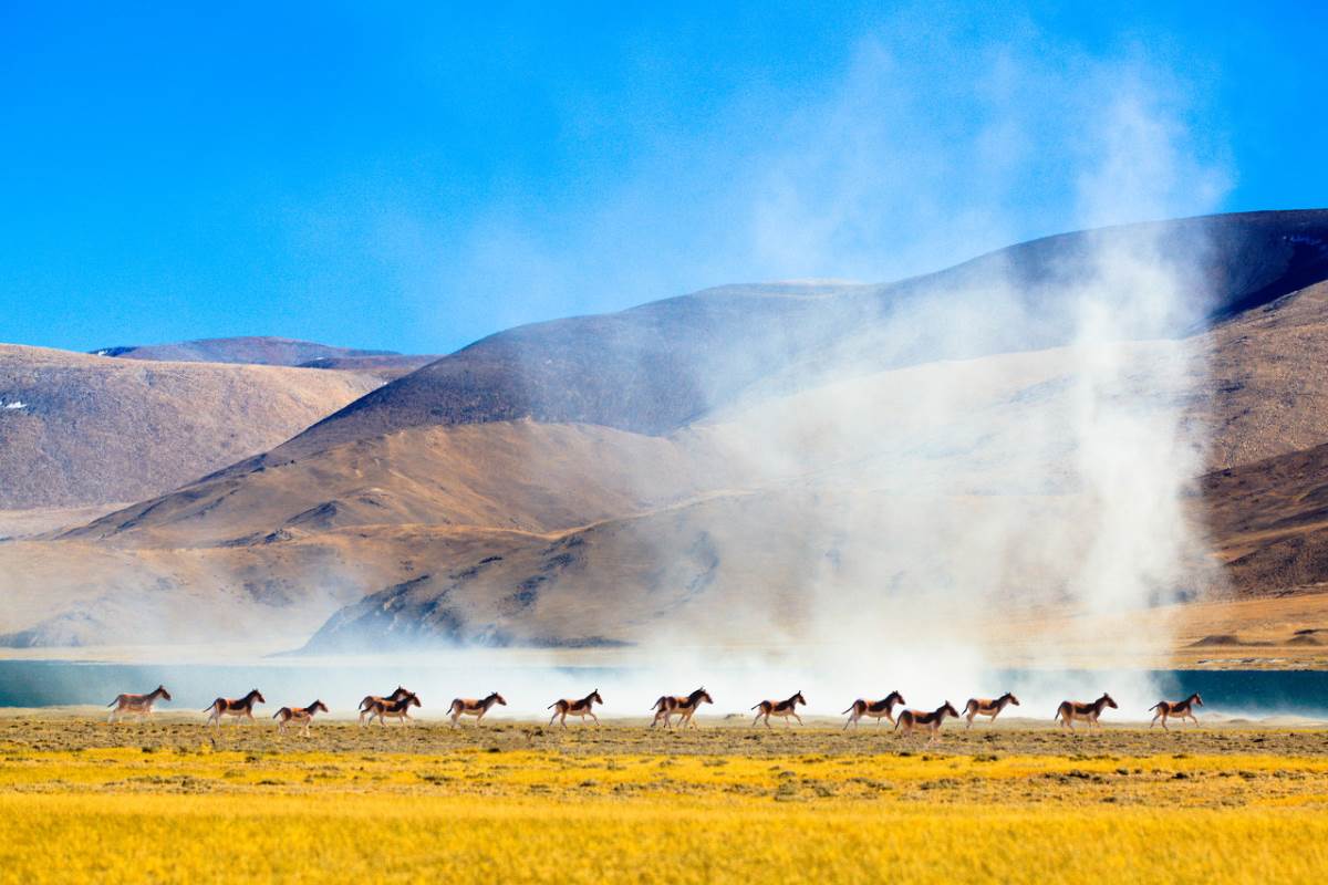
- $1280.00
- 9D8N DAYS
01. A top classic pilgrimage route and experience the best religious atmosphere in China, all across the region, throughout the year, Tibetan pilgrims can be seen walking, riding, or even prostrating along the side of the road towards their …
Read More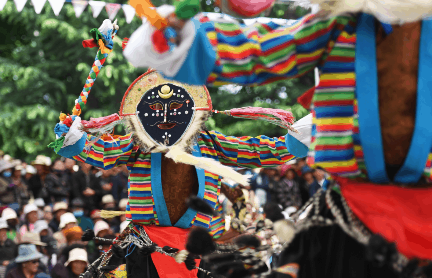
- $1280.00
- 7D6N DAYS
01. Specially arrange a 3days tour in Lhasa to hava a deep experience of the various kinds of Tibetan Culture, also a very good opportunity to shoot the local people.02. Count the steps up to the Potala Palace — the holy palace of Tibetan B…
Read More