- Xinjiang -
China's largest province, Xinjiang is the homeland of the Muslim Uyghurs and a fast-changing region where ancient and modern grind up against each other in surprising ways. High-speed railways cross the Martian landscapes linking cities in hours rather than days, and the regional capital Urumuqi is a forest of high-rise apartments and glass skyscrapers; while in parts of the Silk Road oases of Kashgar, Hotan and Turpan, life goes as it has for centuries, based around the mosque, the tea house and the bazaar.
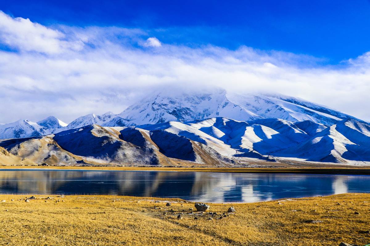
Xinjiang is increasingly attracting visitors for its extraordinary natural beauty and fascinating Central Asian history and culture.

Basic Information
Chinese Name: 新疆( Xin Jiang )
Administration Type: Autonomous Region
Provincial Capital: Urumqi
Location: North western of China, bordered by eight countries including the former Soviet Central Asian republics, Mongolia, Afghanistan, Pakistan and India.
Area: Xinjiang spans over 1.6 million km2 (640,000 square miles)
Population: The 2010 census shows Xinjiang as having 21.82 million people.
Major Ethnic Group: Uyghur, Han, Kazakhs, Tibetans, Hui, Tajiks.
Famous Cities: Urumuqi, Turpan, Kashgar, Altay.
Xinjiang Geography
Xinjiang is the largest political subdivision of China—it accounts for more than one sixth of China's total territory and a quarter of its boundary length. Xinjiang is mostly covered with uninhabitable deserts and dry grasslands, with dotted oases at the foot of Tian Shan, Kunlun Mountains and Altai Mountains. The inhabitable oasis accounts for 9.7% of Xinjiang's total area by 2015.
Xinjiang is young geologically. Collision of the Indian and the Eurasian plates formed the Tian Shan, Kunlun Shan, and Pamir mountain ranges. Xinjiang is a very active earthquake zone. Older geological formations are located in the far north, where the Junggar Block is geologically part of Kazakhstan, and in the east, where is part of the North China Craton.
Xinjiang Climate
A semiarid or desert climate prevails in Xinjiang. The entire region has great seasonal differences in temperature with cold winters. The Turpan Depression recorded the hottest temperatures nationwide in summer,with air temperatures easily exceeding 40 °C (104 °F). Winter temperatures regularly fall below −20 °C (−4 °F) in the far north and highest mountain elevations.
Continuous permafrost is typically found in the Tian Shan starting at the elevation of about 3,500–3,700 m above sea level. Discontinuous alpine permafrost usually occurs down to 2,700–3,300 m, but in certain locations, due to the peculiarity of the aspect and the microclimate, it can be found at elevations as low as 2,000 m.
Xinjiang Religion
The major religions in Xinjiang are Islam among the Uyghurs and the Hui Chinese minority, while many of the Han Chinese practice Chinese folk religions, Taoism, Confucianism and Buddhism. According to a demographic analysis of the year 2010, Muslims form 58% of the province's population.Christianity in Xinjiang is the religion of 1% of the population according to the Chinese General Social Survey of 2009.
A majority of the Uyghur Muslims adhere to Sunni Islam of the Hanafi school of jurisprudence or madhab. A minority of Shias, almost exclusively of the Nizari Ismaili (Seveners) rites are located in the higher mountains of Pamir and Tian Shan. In the western mountains (the Pamirs), almost the entire population of Pamiris, (Sarikolis and Wakhis) are Nizari Ismaili Shia. In the north, in the Tian Shan, the Kyrgyz and Kazakhs are Sunni.
Afaq Khoja Mausoleum and Id Kah Mosque in Kashgar are most important Islamic Xinjiang sites. Emin Minaret in Turfan is a key Islamic site. Bezeklik Thousand Buddha Caves is a noticeable Buddhist site.
Xinjiang Cuisine
As the largest autonomous region in China, Xinjiang boasts substantial contingencies of different ethnic groups and is well-known for its Central Asian flair. Its cities are dominated by the Uyghur ethnic minority, as well as several other Muslim groups such as the Hui and Dongxiang people, meaning the food is predominantly halal and there is a marked lack of pork compared to other parts of China. In many ways, the cuisine in Xinjiang differs from the rest of the country and is distinctly non-Chinese. Roasted mutton, thickly fragrant spices, and sugary sweet desserts take centre stage when it comes to its signature dishes.
Since many of the cities within Xinjiang were once oasis towns along the Silk Road, they felt the influence of other ethnic groups most profoundly and have cherry-picked features of their cuisine, incorporating techniques and flavours from the Tibetans, Mongolians, Persians, Turkish, and numerous other nationalities. These have all come together to form a stunning mosaic of Chinese, Central Asian, and Middle Eastern qualities. Liberal use of seasonings like cumin, chilli powder, cinnamon, garlic, and saffron sets Xinjiang cuisine apart from other styles throughout China.
Xinjiang cuisine reflects the cooking styles of many ethnic groups of the Xinjiang region, and refers particularly to Uyghur cuisine. Signature ingredients include roasted mutton, kebabs, roasted fish, and rice.Because of the Muslim population, the food is predominantly halal.
Folk Festivals
Corban Festival (Muslim People)
Corban is an important festival for Muslims. Corban Festival is also called Zaishengjie while the Hui people call it Zhongxiaojie (festival of faith and obedience). It comes 70 days after the Feast of the Fast Breaking, or the tenth day of the second month in the Islamic calendar. The festival bears the meaning that disciples will devote everything to show their obedience and faith to Allah.
Grape Festival (Uygur People)
The Grape Festival is not just an ode to Turpan`s most important agricultural product, but a chance to celebrate the local way of life. Expect plenty of cultural treats in this remote corner of Xinjiang China. This oasis town in Eastern Xinjiang is picturesquely covered in vine trellises, shading the friendly locals from some of the fiercest heat in China. Almost every household has a hand in the grape business and the markets are full of sweet dried raisins. Its a relaxing place where donkey carts still outnumber cars, but it livens up in April each year.
Eid ul-Fitr (Muslim People)
Eid ul-Fitr often abbreviated to Eid, is a three-day Muslim holiday that marks the end of Ramadan, the Islamic holy month of fasting (sawm). The holiday celebrates the conclusion of the thirty days of dawn-to-sunset fasting during the entire month of Ramadan. The first day of Eid, therefore, falls on the first day of the month Shawwal.
Nowruz Festival
Nowruz Festival is celebrated as the traditional New Year for Uyghurs, Kazaks, Kirgiz, and Uzbeks in China’s Xinjiang region. It is celebrated around March 21st, which is the first day of spring, and the beginning of the year on the Iranian calendar. This festival is celebrated in many countries like Iran, Afghanistan, Kurdish regions of Iraq, Turkey and central Asian countries. It marks the beginning of the planting season. There are several traditional activities that the people take part in. In one activity, the head of the family waves burning pine and fir branches over the heads of the family. There is a traditional Nowruz porridge, “Harach” that is made from many ingredients that is served at lunch. There are many different traditional performances and celebrations that include singing, dancing, wrestling, and acrobatics.
Altay Prefecture
Altay Prefecture is in Xinjiang is on the north border of Xinjiang Uyghur Autonomous Region, connected with Mongolia to the north. The Altay city is the political, ecnomic and cultural center of Altay Prefecture. The cow, horse and sheep raising take large account in the grassland farming of Altay.
Altay Prefecture is located in Northern Xinjiang, People's Republic of China. It has an area of 118,015 km2 and a population of 561,667 (2000). It is a part of Ili Kazakh Autonomous Prefecture. At the 2000 census, Altay was the only major subdivision of Ili Kazakh Autonomous Prefecture with an ethnic Kazakh majority.
Kanas Lake is a lake in Altay Prefecture, Xinjiang, China. The lake is located in a valley in the Altai Mountains, near the very northern tip of Xinjiang and the province's borders with Russia, Kazakhstan and Mongolia. The lake was formed around 200,000 years ago during the Quaternary period as a result of glacier movement. The crescent moon shaped lake has an estimated water storage capacity of 53.8 billion cubic meters, coupled with an average depth of around 120 meters.
The Kanas River, flowing out of the lake, later merges with the Hemu River to form the Burqin River, which itself discharges into the Irtysh River at Burqin Town, the county seat of Burqin County.

The Altay region boasts rich landscape forms, from glacial rivers, forests and grasslands to alpine valleys, lakes, wetlands and deserts.With three five-A scenic attractions including the well-known Kanas Lake, as well as more than 200 quality tourist destinations scattered along the picturesque Altay Mountains, the Altay area is regarded as one of the most promising tourist markets in Xinjiang.
Sublime glaciers and snow-covered peaks, colorful alpine meadows, grand granitic natural sculptures, dynamic atmospheric conditions, picturesque landscapes of rivers and lakes, and charming nomadic life and folk customs. These features combine to form unique aesthetic values that are second-to-none. The area is a remarkable exemplification for the aesthetic values of integrated natural and human mountainous landscape.
The most beautiful and the most concentrated Altay tourist attractions gather in northern Burqin county, mainly including Kanas Scenic Spot, Hemu Village, Baigaba Village, Colorful Beach Scenic Spot, etc. In east, there are two splendid tourist destinations -- Koktokay and Palette Town. Besides, there are other tourist spots scattered around the Altay city, loke Hualin Park, Xiaodonggou Forest Park , Wuzhiquan Scenic Spot, etc.
Main Cities of Altay
Altay City
Altay city is located at the southern foot of the Altai Mountains and the northern edge of the Junggar Basin, so the northern part of the city is higher than the southern part. The landform of the city mainly consists of the northern mountainous areas, the southern hilly area and the alluvial plain among mountains.
Altay is endowed with rich natural resources and is thus reputed as "gold mountain". There are over a hundred of rivers of all sizes lie in this city with three big river systems: Irtysh River, Kelan River and Sumudayilie River running through making it a natural reservoir of water.
Altay attracts visitors with its picturesque landscape. The famous Kanas Lake, known as the oriental Sweden, boasts charming lakes, snowy mountains and verdant plants. The Irtysh River originating from the Altai Mountain, flows through Altay and finally flows into the Arctic Ocean. It is the second longest river in Xinjiang and famous for the beautiful scenery. There are also many rivers, lakes and grassland. Further more, over 60 sites of ancient cliff paintings, sarcophagus and tombs have been discovered, from which visitors can learn more about the history of the area.

Burqin County
Burqin County is located in the northernmost part of Xinjiang. Its county seat, which is called Burqin Town (布尔津镇) is situated at the confluence of the Irtysh and its right tributary, the Burqin River. Most of the county is within the Burqin River basin, which reaches into the Altai Mountains on Xinjiang's border with Mongolia and Russia. The major mountain massif on Burqin county's border with these two countries is Tavan Bogd.
Burqin lies along the route to Kanas and Hemu. Burqin is a beautiful small city where the architecture and the plants and flowers lining the roads make you feel like you are in a garden. Famous sites include the yardang landscape of Aketubieke, the glacier on Friendship Peak, Kanas Lake, the Tuluke petroglyphs, and Rainbow Beach.

Fuyun County
Fuyun County is located in northern Xinjiang Uygur Autonomous Region, is under the administration of the Altay Prefecture, with an area of 32,237 square kilometers, bordering Green River County at the east and Fuhai County and Beitun Town at the west.Situated at northeast of Junggar Basin in Xinjiang, Fuyun County borders Mongolia in the north. The 82,900 population is composed by 29 nationalities among which Kazak takes 65%.
Honoured as the "Chinese Yosemite", Koktokay National Geopark is located 56 kilometers from Fuyun County, Featuring beautiful natural scenery such as valleys, rivers, peaks, forests, mines, and seismic belts, the park was listed as a UNESCO World Geopark in 2017.

- $2280.00
- 12D11N DAYS
01. A historical relicss of the ancient silk road tour in south Xinjiang, Experience a bazaar that has existed for centuries on the Silk Road, enjoy kebabs in the night market while Uyghur music and dance videos blare from the vendors, explo…
Read More
- $1380.00
- 10D9N DAYS
01. Enjoy the beautiful and mysterious Kanas Lake, a heavenly oasis in Xinjiang desert,famous as the “Oriental Switzerland” and the paradise of photographers; The "treasure Light" integrates with the beautiful Kanas Lake view, th…
Read More
- $USD868.00
- 7D6N DAYS
01. A historical relicss of the ancient silk road tour in south Xinjiang, Exploring the hub connecting China to Central Asian countries, stroll around the Old Town, to explore the special culture of local people in Kashgar. Experience a baza…
Read More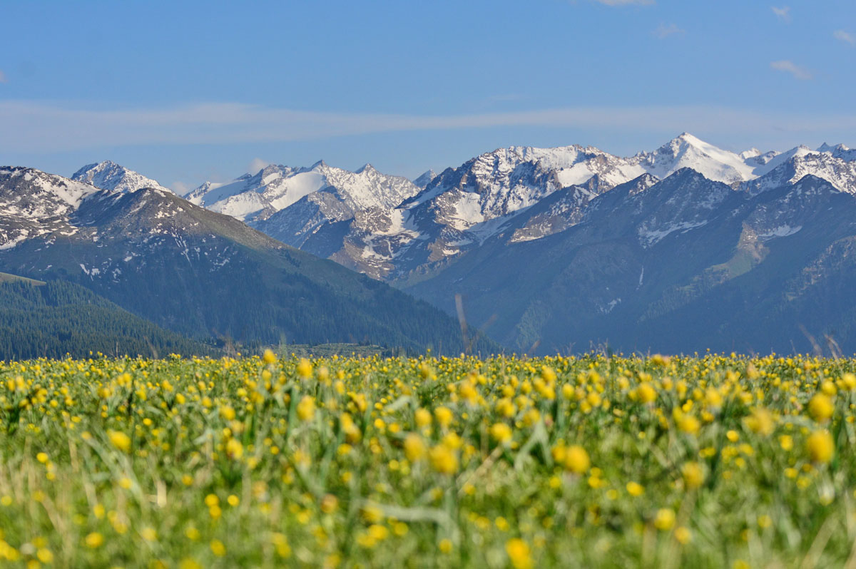
- $1658.00
- 12D11N DAYS
01. A tour travel deep into remote Xinjiang grasslands in the best time, including Sayram lake, Xiata Grand Canyon, Kalajun Pasture, Nalati Grassland, Bayanbuluk, winding river, large flat valley, towering and steep mountain peaks, dense fo…
Read More